具体描述
| 宝贝信息 |
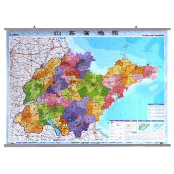
| 书名: | 山东省地图 |
| 出版: | 星球地图出版社 |
| 内容: | 吉林省政区交通 地理位置 地形特征以及气候特点等内容 |
| 卖点: | 标注了高速 国道省道及县乡道 铁路高铁及车站 本省行政区划统计(市辖区 自治县和市辖县 人口面积) |
| ISBN: | 9787802127319 |
| 审图号: | JS(2009)01-299号 |
| 版次: | 2018修订印刷 |
| 语种: | 中文 |
| 比例尺: | 1:75万 |
| 尺寸: | 1.1*0.8米 |
| 定价: | 40元 |
| 装帧: | 双面覆亮膜 整张地图 |
| 包装: | pvc 塑料管包装 |
《 Shandong Province: A Comprehensive Atlas of Administration and Transportation 》 This meticulously crafted atlas offers an in-depth exploration of Shandong Province, a region of immense historical significance and burgeoning economic dynamism in China. Designed for a broad audience, from seasoned scholars and diligent students to curious travelers and astute business professionals, this atlas serves as an indispensable guide to understanding the intricate administrative divisions and extensive transportation networks that define Shandong. Navigating the Administrative Landscape: At its core, this atlas presents a detailed and up-to-date portrayal of Shandong Province's administrative geography. The maps are painstakingly rendered to reflect the latest governmental classifications, ensuring accuracy in delineating prefectural cities, counties, and districts. Each administrative unit is clearly labeled, providing an immediate understanding of the hierarchical structure that governs the province. Beyond mere identification, the atlas delves into the nuances of each administrative region. For prefectural cities, it highlights their respective administrative centers, key sub-districts, and townships, offering a granular view of urban and rural organization. The maps showcase the geographical distribution of these units, illustrating their spatial relationships and the administrative boundaries that separate them. Furthermore, the atlas dedicates significant attention to the historical evolution of these administrative divisions. Where relevant, it offers insights into past administrative arrangements, helping users to appreciate the long-term development and administrative reforms that have shaped Shandong's contemporary structure. This historical context is crucial for understanding regional identities, local governance, and the territorial integrity of various administrative entities. The atlas also provides key demographic and economic data for each administrative unit, such as population density, major industries, and significant cultural landmarks. This integration of geographical and socio-economic information transforms the atlas from a simple map into a comprehensive informational resource, enabling users to grasp the multifaceted characteristics of each administrative area. The atlas is particularly adept at illustrating the intricate relationship between administrative boundaries and the natural environment. Rivers, mountains, lakes, and coastlines are depicted with precision, showing how geographical features have historically influenced and continue to shape administrative divisions. This interplay between human organization and natural geography offers a deeper understanding of regional development patterns and resource management. Mastering the Transportation Arteries: Complementing its detailed administrative mapping, this atlas provides an exhaustive depiction of Shandong Province's transportation infrastructure. The network of highways, railways, and waterways is illustrated with exceptional clarity, showcasing the arteries that connect communities and facilitate economic activity. The highway system is comprehensively mapped, distinguishing between national, provincial, and county-level roads. Major expressways are prominently featured, highlighting their routes, interchanges, and key cities they connect. This allows for a clear understanding of the province's high-speed transportation backbone. The atlas also maps secondary and tertiary roads, providing a nuanced view of local connectivity and the accessibility of smaller towns and villages. For each major highway, important service areas, rest stops, and points of interest are indicated, adding practical value for travelers. The railway network is equally well-represented, depicting high-speed rail lines, conventional passenger lines, and freight routes. The locations of major railway stations, marshalling yards, and significant junctions are clearly marked. The atlas illustrates the integration of rail transport with other modes of transportation, such as ports and airports, revealing the strategic importance of these hubs in the province's logistics chain. Shandong's extensive network of rivers and canals, particularly its historical significance for trade and transportation along the Grand Canal, is also meticulously charted. The maps showcase major navigable waterways, ports, and ferry terminals, illustrating the vital role of waterborne transport in connecting inland regions with coastal areas and facilitating inter-provincial trade. Furthermore, the atlas includes the locations of major airports, detailing their passenger and cargo capacities, as well as the cities they serve. The integration of air, rail, and road networks is a key feature, demonstrating the seamless connectivity that characterizes modern Shandong. This comprehensive depiction of the transportation infrastructure is invaluable for logistical planning, business development, and understanding the movement of goods and people across the province. A Wealth of Supplementary Information: Beyond its core cartographic content, this atlas is enriched with a variety of supplementary information designed to enhance user comprehension and utility. Each map is accompanied by descriptive text that provides context and detail. For administrative maps, this text might elaborate on the history, culture, and economic specialties of specific regions. For transportation maps, it could offer statistics on passenger and freight volumes, information on transportation policies, or details about future transportation development plans. The atlas includes a comprehensive index of place names, allowing users to quickly locate any city, town, county, or district within the province. This index is cross-referenced with map coordinates, ensuring swift and accurate navigation. Additionally, a glossary of geographical and administrative terms is provided, clarifying any specialized terminology used within the atlas. Key geographical features, such as major mountains, rivers, and lakes, are annotated with their names and relevant elevations or lengths, offering a deeper appreciation of Shandong's natural landscape. Tourist attractions, historical sites, and significant cultural heritage locations are also highlighted, making the atlas a valuable companion for cultural exploration and tourism. Precision, Clarity, and Durability: This atlas is produced with a commitment to the highest standards of cartographic accuracy and printing quality. The maps are rendered using state-of-the-art GIS technology, ensuring precision in scale, projection, and data representation. The use of high-resolution printing techniques brings out the finest details, making the maps visually clear and easy to read. The substantial dimensions of the atlas – 1.1 meters by 0.8 meters – provide an expansive canvas for detailed mapping, allowing for a comprehensive overview of the entire province without sacrificing the clarity of individual regions. This generous size makes it ideal for wall mounting, facilitating easy reference and collaborative study in offices, classrooms, or libraries. The atlas is further enhanced by a double-sided lamination, a crucial feature that ensures its durability and longevity. This protective coating guards against wear and tear, moisture, and accidental damage, making it suitable for frequent use in diverse environments. The smooth, wipeable surface also simplifies maintenance, allowing for easy cleaning and preservation of the map's pristine condition over time. This thoughtful design choice underscores the atlas's intended use as a long-term reference tool. Target Audience and Applications: The breadth and depth of information contained within this atlas make it an indispensable resource for a wide array of users: Academics and Researchers: For geographers, historians, sociologists, and political scientists studying Shandong Province, this atlas provides essential spatial data and administrative context for their research. Students: From primary school geography lessons to university-level studies, the atlas offers a clear and engaging visual aid for learning about Shandong's geography, administrative structure, and transportation networks. Business Professionals: For companies operating in or considering investment in Shandong, the atlas is crucial for understanding market accessibility, logistical challenges, and the distribution of economic activity across different administrative regions. Government Officials and Planners: This atlas serves as a vital tool for regional planning, policy formulation, and administrative management, providing accurate geographical and infrastructural data. Tourists and Travelers: For those planning to visit or explore Shandong, the atlas offers a comprehensive guide to navigating the province, understanding regional differences, and identifying points of interest. Anyone Interested in China: As a representative of a key Chinese province, this atlas offers a valuable window into the complexities of China's administrative system and its vast transportation infrastructure. In conclusion, this comprehensive atlas stands as a definitive resource for anyone seeking a deep and nuanced understanding of Shandong Province. Its meticulous cartography, extensive administrative and transportation data, and durable, user-friendly design make it an unparalleled tool for education, research, business, and personal exploration. It is a testament to the province's rich heritage and its dynamic modern development.


![户外生存自救图解手册:你最需要知道的175个小技巧 [show me how to survive] pdf epub mobi 电子书 下载](https://pic.tinynews.org/11334851/rBEhVlKJcoUIAAAAABEFfNzkX9sAAFvPwOUqDMAEQWU606.jpg)