具体描述
产品特色
编辑推荐
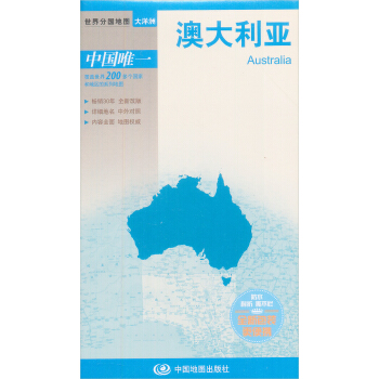
全国大幅面地图(865mm×1170mm),中外文对照;
《世界热点国家地图·》的字号比我社常规出版的地图都要大很多,版面设计美观大方,有更好的阅读体验,适合各界读者的使用需求;
添加了海运交通、世界遗产、大学等信息,针对需要了解世界各国情况、从事国际事务、商务、经济贸易、学术等研究工作的人群,或者是出国留学、访问、旅游的读者;
折叠袋装,折挂两用,便于携带。
海报:
内容简介
新出版的“世界热点国家地图”共17张,涵盖了大部分世界的热点国家和地区。内容上表示了各国家和地区的行政区划、区域界线、交通、旅游等信息,为需要了解世界各国情况、从事国际事务的人群,以及出国留学、访问、旅游的读者打开一扇了解世界的窗口,架设起一座传递信息的桥梁。
其特点是:内容上新增了港口、航海线,完善了海运交通信息;新增了世界遗产和主要景点;新增了各国家主要大学。形式上为大全开折叠图,方便携带。《世界热点国家地图》特点是字号大,方便读者读图。
作者简介
中国地图出版社成立于1954年,是我国专业级别的地图出版社,是编制中国政区图和世界政区图的专业机构,为维护祖国的主权和尊严发挥了不可替代的作用。中国地图出版社编制出版的历史、地理、交通、旅游类地图,是深受广大读者喜爱的品牌产品,为丰富人民群众的精神文化生活作出了贡献。中国地图出版社已出版地图、书刊8000多种,发行量超过了101亿册(幅),编制出版了许多具有较高学术价值的地图。
内页插图
前言/序言
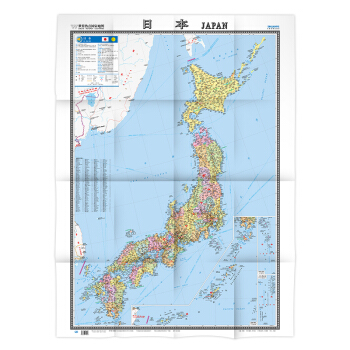
《世界热点国家地图:日本》—— unfolding the Land of the Rising Sun Embark on an immersive journey to Japan with "World Hotspot Countries Map: Japan," a meticulously crafted geographical guide designed for both the curious traveler and the dedicated scholar. This comprehensive map, presented in a convenient fold-and-hang format, offers an unparalleled window into the diverse landscapes, rich history, and vibrant culture of this fascinating island nation. A Visual Tapestry of Japan's Geography: The heart of this map lies in its detailed and accurate depiction of Japan's topography. Spanning an impressive 865mm by 1170mm, the map unfurls to reveal a nation sculpted by volcanic forces and embraced by the vast Pacific Ocean. Major mountain ranges, such as the majestic Japanese Alps (Nihon Alps), are rendered with striking clarity, showcasing their rugged peaks and deep valleys. Prominent peaks like Mount Fuji, Japan's iconic stratovolcano, are clearly marked, inviting exploration and admiration. Rivers, the lifeblood of any nation, are traced with precision, from the mighty Shinano River, the longest in Japan, to countless smaller tributaries that nourish the land. The intricate network of waterways highlights the importance of water in Japanese agriculture, transportation, and daily life. Coastal features are equally well-defined, illustrating the extensive coastline characterized by numerous bays, peninsulas, and islands. From the northern reaches of Hokkaido with its dramatic fjords and rugged shorelines to the subtropical beauty of Okinawa in the south, the map captures the varied coastal environments. Island Nation, Island Diversity: Japan's identity as an archipelago is brought to life by the clear delineation of its four main islands: Hokkaido, Honshu, Shikoku, and Kyushu. Each island is presented with its unique geographical characteristics. Hokkaido, in the north, showcases its vast plains, volcanic landscapes, and abundant forests, hinting at its wilder, less densely populated character. Honshu, the largest and most populous island, reveals the concentration of major cities, extensive agricultural regions, and the backbone of the Japanese Alps. Shikoku, the smallest of the main islands, displays its mountainous interior and charming coastal towns. Kyushu, the southernmost of the main islands, is depicted with its volcanic activity, subtropical flora, and historical significance as a gateway to Asia. Beyond the main islands, the map also identifies and places numerous smaller islands and island groups, underscoring the vastness of Japan's territorial waters and the geographical complexity of the nation. This detailed representation allows for an understanding of the archipelago's interconnectedness and the unique ecological niches found across its diverse islands. Key Cities and Administrative Divisions: At the core of geographical understanding is the identification of human settlements and administrative structures. "World Hotspot Countries Map: Japan" excels in this regard. Major metropolises like Tokyo, the bustling capital, Osaka, the nation's culinary heart, and Nagoya, a key industrial center, are prominently featured. Their intricate urban sprawl is suggested through the visual density, while their administrative boundaries are subtly indicated. Beyond the megacities, a comprehensive array of smaller cities, towns, and villages are marked, providing a granular view of Japan's settlement patterns. This level of detail is invaluable for understanding regional development, population distribution, and the historical evolution of urban centers. The map also clearly outlines Japan's administrative divisions, including its prefectures. Each prefecture, the primary administrative unit, is distinctly colored or bordered, allowing for easy identification and comprehension of Japan's governmental structure. Key prefectural capitals are also marked, further enhancing the map's utility for administrative and organizational purposes. Transportation Networks: Connecting the Archipelago: A nation's infrastructure is a vital component of its geography, and Japan's advanced transportation network is a testament to its technological prowess and commitment to connectivity. This map meticulously illustrates the extensive railway system, including the iconic Shinkansen (bullet train) lines, which crisscross the country at remarkable speeds. The efficient and widespread nature of Japan's rail network is visually apparent, highlighting its importance for both domestic and international travel. Major highways and expressways are also clearly depicted, illustrating the arterial routes that connect cities and regions. The map shows how these modern infrastructure projects have shaped Japan's landscape and facilitated economic growth. Airports, seaports, and ferry terminals are also marked, indicating the crucial role of air and sea transportation in connecting Japan to the rest of the world and its many islands. The inclusion of these transportation hubs provides a comprehensive understanding of how people and goods move across and beyond Japan. Natural Wonders and Points of Interest: Beyond the urban centers and infrastructure, "World Hotspot Countries Map: Japan" unveils the country's breathtaking natural beauty and significant cultural landmarks. National parks, protected areas renowned for their pristine ecosystems and stunning scenery, are clearly identified. These regions, such as Fuji-Hakone-Izu National Park or Daisetsuzan National Park in Hokkaido, represent vital conservation efforts and offer opportunities for outdoor recreation and appreciation of Japan's natural heritage. Major lakes, such as the serene Lake Biwa, Japan's largest freshwater lake, and the picturesque volcanic lakes of the Fuji Five Lakes region, are depicted, adding to the geographical richness of the map. Volcanoes, both active and dormant, are clearly marked, reminding viewers of Japan's position on the Pacific Ring of Fire and the dynamic geological forces that have shaped its land. For those interested in Japan's rich history and cultural tapestry, the map also highlights significant historical sites and cultural attractions. Ancient castles, serene temples, and vibrant shrines are noted, offering a glimpse into Japan's storied past and its enduring spiritual traditions. These markers serve as invitations to explore the historical and cultural depth that lies beneath the surface of this modern nation. Bilingual Accessibility and User-Friendly Design: Understanding the diverse needs of its users, "World Hotspot Countries Map: Japan" is presented with a bilingual approach, featuring both Japanese and Chinese (Simplified) text. This dual-language presentation ensures accessibility for a wide range of individuals, from Japanese speakers and Mandarin speakers to those who may be learning either language. The clear and prominent display of place names and geographical features in both scripts facilitates comprehension and navigation, making the map an invaluable resource for a global audience. The map's commitment to user-friendliness is further evident in its large, easy-to-read font. This consideration ensures that all information is readily decipherable, even from a distance, making it ideal for classroom settings, public spaces, or for individuals who may have visual impairments. The thoughtful design prioritizes clarity and readability, allowing users to focus on the geographical information without strain. Versatile Format: Folded Convenience, Wall Display Elegance: The "World Hotspot Countries Map: Japan" is not merely a source of information but also a practical and versatile tool. Presented in a folding format, it is easily portable, making it an ideal companion for travel, study, or on-the-go reference. The robust folding mechanism ensures durability, allowing the map to withstand repeated use without compromising its integrity. Simultaneously, the map is designed for elegant display. When unfolded, its generous dimensions transform it into a striking wall map. The clear cartography and appealing design make it a visually engaging addition to any room, whether it be a study, classroom, or living space. This dual functionality—practical portability and aesthetic display—caters to a wide spectrum of user preferences and applications. An Indispensable Resource for Exploration and Understanding: "World Hotspot Countries Map: Japan" transcends the definition of a simple map. It is a gateway to understanding a nation characterized by its unique blend of tradition and modernity, its striking natural beauty, and its profound cultural heritage. Whether you are planning a trip, conducting research, or simply seeking to expand your geographical knowledge, this meticulously detailed and user-friendly map provides an unparalleled visual and informational resource. It invites you to explore the intricate contours of the Japanese archipelago, to connect with its vibrant cities and serene landscapes, and to embark on a journey of discovery within the captivating realm of Japan.


![中国最美100个古镇古村 [100 Most Beautiful Ancienttowns And Villages of China] pdf epub mobi 电子书 下载](https://pic.tinynews.org/11956430/575fca12N64d04427.jpg)


![中国秘境之旅:最美婺源 [The Pearl on Exquisite Tourist Routes] pdf epub mobi 电子书 下载](https://pic.tinynews.org/11153893/rBEHZVDtB7EIAAAAAAhdVIZqG6AAADkOQCyLyoACF1s152.jpg)